
Nos campagnes océanographiques en 2023
Direct access to the 2023 marine cruises, by clicking below:
Marine expedition FOCUS-G3
Chief scientist : Jean-Yves Royer (Geo-Ocean – UMR 6538)
Partners :
- Laboratoire LIttoral ENvironnement et Sociétés (LIENSs - UMR 7266) (La Rochelle)
- Geomar Institute (Kiel)
- Laboratori Nazionali del Sud dell’INFN (Catane)
- Université de Catane, Département des Sciences Biologiques, Géologiques et Environnementales (DBS)
Geographical zone : Mer Ionienne, au large de la Sicile (côte Est)
Dates : 20 au 26 août 2023
Ship : N/O Téthys II
Equipment :
- Acoustic beacon communication modems
- Ultra-short baseline system coupled to an inertial navigation system (beacon positioning)
- CTD (conductivity, temperature, depth)
- Unmanned surface vehicle (drone)
- Ocean-bottom seismometers (to be recovered)
Objectives :
The FOCUS-G3 expedition is part of the ERC FOCUS project (2020-2025) to monitor the North Alfeo Fault, off Mount Etna in the Ionian Sea. The project aims to measure fault displacements using laser reflectometry through a fiber-optic cable connected onshore. To calibrate these measurements, acoustic beacons have been installed on both sides of the fault, near the fiber-optic cable, to measure the relative displacement (acoustic telemetry). The fiber optic and beacons were deployed in October 2020. Following their untimely shutdown, the beacons had to be recovered in 2022 and were redeployed in early 2023.
FOCUS G3 follows FocusX3 on R/V L'Atalante in February 2023, during which 13 acoustic beacons (network 1 or LGO) and fiber-optic cables were redeployed on both sides of the fault. A second network of acoustic beacons (called network 2 or Geomar) from the GEOMAR Institute was installed in December 2021 on another segment of the fault, on the eastern flank of Etna. In addition to the displacement measurements, a network of ocean-bed seismometers (OBS) monitors the seismic activity of the fault.
Main objectives of FOCUS-G3:
- Download from the surface, the data acquired by the acoustic beacons since February 2023 (networks 1 and 2), using an acoustic modem. The acoustic stations will remain in place until 2025;
- Very precisely position some acoustic beacons from Network 1 to measure their possible displacement relative to permanent GPS stations installed on land. The stations will be positioned using an autonomous surface drone piloted from the ship and equipped with a very precise positioning system. CTD profiles will be acquired simultaneously in order to track velocity variations over time; this is necessary for acoustic positioning;
- Recover 5 ocean-bottom seismometers deployed in February 2023 (Focus-X3);
- Time and weather permitting, acquire CTD profiles on the return transit to Catania (3D celerity variations).
FOCUS-G3 will ensure that the acoustic beacons always function nominally to complete the relative and absolute positioning time series. These recordings will be repeated in 2024. In addition to the geodynamic and methodological implications of the project (fibre vs. acoustics), the objective is to demonstrate that measuring absolute movements of the seabed of the order of cm/year is possible.
Access to the French Oceanographic Cruises Catalogue: Marine Expedition FOCUS-G3
Marine expedition AMANAUS
 Chief scientists :
- Geophysical survey boat: Marina Rabineau, Daniel Aslanian (Joint Research Unit Geo-Ocean, CNRS-Ifremer-Université de Brest), Agnès Baltzer (Université de Nantes, LETG)
- Hydrogeological survey: Jean-Michel Martinez (IRD)
Partners :
- Brazil :
- University of Brasilia - CPRM (Marco Ianniruberto, Roberto Santos),
- University of Santarem - UFOPA (Cintia Rocha de Trinidade),
- University of Manaus – UFAM (Michele Andriolli Custódio, Naysiano Filizola)
- France :
- University of Toulouse - DEEP (Jérome Murienne),
- University of Montpellier - Bioinformatics & Biomarkers (Thérèse Commes)
- Non-scientific partners:
- Celine Desmoulière,Landscape Architect in charge of the travel journal. Her sketched watercolour journal will be published in the near future. To see more of her work click here.
- Laurence Monroe is a documentary scriptwriter. We met Laurence during the shooting of her first scientific documentary film for which she received the Ushuaïa TV First Scientific Film Award in 2021 at Pariscience and we discussed our plans to make a documentary film on the Amanaus mission. She gladly and kindly accepted our offer.
Geographical zone: The Amazon River
Dates : 05-25 July 2023
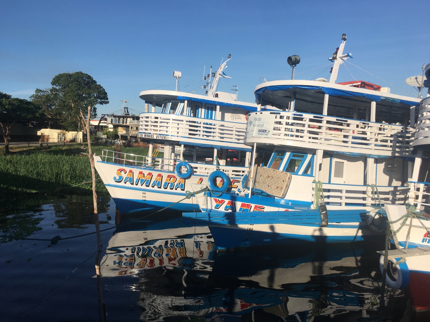
Ships of opportunity: Samara Lopez XII (geophysics) & Yane Jose (hydrogeology)
Equipments : Multibeam echosounder, Ronansberg corer, sparker & seismic streamer, small grab, pump and filter (ADN)
Objectives :
 AMANAUS took place from 5th to 25th July 2023 on two boats: The Samara Lopes XII and the Yane Jose IV from Manaus to Santarem and on the Samara Lopes XII only on the way back from Santarem to Manaus.
The expedition developed from international collaboration between Brazilian and French researchers:
- The Yane Jose IV made hydrological measurements under the HYBAM programme with members of the ANA, the CPRM and the IRD (www.ore-hybam.org/),
- while the Samara Lopes XII conducted geophysical-geological measurements financed by ISBlue EUR school, ANR, CAPES-COFECUB.
The objective of the survey was to deploy tools never used in the Amazon River to acquire new geophysical data (bathymetry and high-resolution multibeam seismic), sedimentological and geochemical data (cores, sediment bedloads and suspended particles) for a better understanding of the transport of sediments from source to sink and their evolution over time with the concomitant roles of climate, sea level and tectonic changes.
Access to the French Oceanographic Cruises Catalogue: Marine Expedition AMANAUS
Marine expedition PACTE01
 Chief scientist: Jérôme Goslin (Geo-Ocean – UMR 6538)
Geographical zone: Bay of Brest, estuaries of the rivers Aulne and Elorn
Dates : 03-23 May 2023
Ship : R/V Haliotis
Equipment :
- Interferometric Sonar Geoswath,
- SUb-BOttom Profiler SUBOP
Objectives :
The project PACTE "PAst to Current land-sea Continuum: socio-ecosystem Trajectories derived from a regional pilot site" is an interdisciplinary and multi-governance project (UBO, UBS, Ifremer, CNRS) aimed at reconstructing the trajectory of the socio-ecosystem of the bay of Brest in response to the changes in land use and occupation on the watersheds, and climate change over the past two centuries.
The main objective is to build the first chrono-systemic frieze of the evolution of the socio-ecosystem of the bay of Brest through an integrated and interdisciplinary study combining:
- sedimentological, geochemical, paleo-ecological and paleo-genetic feedback from estuarine sedimentary archives, with
- the analysis of historical records on the use and occupation of watersheds (agriculture, industrial activities), maritime activities (fishing, aquaculture) and major climatic events (storms, extreme temperatures, floods),
- instrumental monitoring of river and coastal water systems, and
- numerical modelling of the physico-biogeochemical trajectory of estuaries within the land-sea continuum (flow, water temperature, concentration, nutrient ratios and flows, oxygenation rate, phytoplankton biomass, etc.).

PACTE01-1, 3-23rd May, 2023 on the Haliotis aimed to collect imagery data and the architecture of estuarine sedimentary bodies in order to:
- Prepare the coring mission PACTE01-2 on board the Thalia between 02 and 05 August 2023
- Provide baseline data for estuary models of present-day bathymetry and sediment geometry of the rivers Aulne and Elorn
285 profiles (sonar and sediment sounder) were obtained, with coverage well upstream into the estuaries (up to the Forest-Landerneau for the Elorn and Dinéault for the Aulne).
Access to the French Oceanographic Cruises Catalogue: Marine Expedition PACTE01
Marine expedition FocusX3
Chief scientist: Marc-André Gutscher (UMR Geo-Ocean, University of Brest, CNRS, Ifremer)
Partners: Geomar (Kiel) ; INGV Rome ; Univ. Catania ; laboratory of physics Catania INFN-LNS.
Geographical zone: Mediterranean, off Sicily, in the Ionian Sea
Dates: 17-27 February 2023
Ship: R/V L'Atalante
Equipment :
- Ocean-bed seismometers (29 recovered, 11 redeployed)
- Geodetic seabed stations (13 deployed)
- ADCP current meter = Acoustic Doppler Current Profiler (1 deployed)
- Multi-beam bathymetry
- Transect CTD (9 stations)
Objectives :
The main objective of the ERC Advanced Grant FOCUS project (October 2018 - September 2025) is to test the application of laser reflectometry, to measure weak, 1 - 2 cm, tectonic displacements consequent to the activity of subsurface faults. Other observation techniques will also be used: seabed geodesy, seismology, micro-bathymetric mapping, sedimentary coring.
- The first phase consisted of connecting and installing a 6-km-long fiber-optic cable through an active submarine fault and a network of 8 geodetic seabed stations to independently quantify the movements of the fault. This was done during FocusX1 in October 2020 with the R/V Pourquoi Pas ? and the Victor6000 ROV.
- The second experimental phase was carried out during FocusX2 (13-28 January 2022, Toulon-Toulon), implementing a passive seismological network of 29 OBS (Ocean-Bottom Seismometers) as well as permanent and temporary terrestrial seismological stations (INGV) and sedimentary coring.
During FocusX3:
- We recovered 29 OBS (14 OBS from the Ifremer Brest/Geo-Ocean pool and 15 OBS from Geomar, Kiel), loaded the data, replaced the batteries, and then redeployed 11 Ifremer OBS (5 broadband OBS for a second 12-month period and 6 LOT-OBS for a 6-month period).
- We deployed two networks of seabed geodetic stations: 5 Geomar acoustic beacons (Sonardyne), and 8 Canopus acoustic beacons (iXblue/Exail).
- We deployed an ADCP (Acoustic Doppler Current Profiler) current meter from the oceanography team at Geomar, Kiel, to measure bottom currents. These instruments will remain on the seabed for 2-3 years until the end of the FOCUS project in 2025 and will be recovered with a ROV.
- We also performed a transect CTD section of temperature and salinity within the water column, with 9 stations, spaced approximately 3 km at 37°29.1’N between 100 m and 2100 m depth.
For more information on FOCUSX3:
- Radio Télévision Suisse, émission CQFD (13/02/2023) : Interview sur la campagne océanographique Focusx3 : La faille sous-marine de l'Etna (Producteur Stéphane Déletroz)
- Radio France Info, émission Le billet Sciences (17/02/2023) : Séismes : une étude lancée pour mieux connaître la faille au large de la Sicile (Animatrice Anne Le Gall)
- Article Le Figaro (24/02/2023) : A bord de L'Atalante pour traquer les séismes en Méditerranée (Journaliste Vincent Bordenave)
- Reportage vidéo sur la mission : Au large de la Sicile, une faille sous haute surveillance (CNRS)
Access to the French Oceanographic Cruises Catalogue: Marine Expedition FocusX3
Marine expedition Manta-Ray 2
") Chiefs scientist: Frauke Klingelhoefer (Joint Research Unit Geo-Ocean, Ifremer), Boris Marcaillou (Géoazur)
Chiefs scientist: Frauke Klingelhoefer (Joint Research Unit Geo-Ocean, Ifremer), Boris Marcaillou (Géoazur)
Partners: Géoazur, University of the West Indies, University of Lorraine, University of Perpignan.
Geographical zone: Northwest Atlantic Ocean, Caribbean Sea
Dates : 09-19th February 2023
Ship: R/V Pourquoi Pas ?
Equipments: Calypso corer, gravity corer, interface corer, gravimeter, magnetometer, multibeam echosounder, sediment sounder
Objectives :
Manta-Ray aims to study the influence of this ultramafic mantle on tectonic deformation, fluid circulations, and seismogenesis of the subduction zone of the Lesser Antilles.
Manta-Ray 2, concentrating on the top of the margin, aimed to compare the composition and force of fluid seeps related to the dehydration of this patch of mantle compared to those related to the dehydration of a mafic crust further south.
We acquired 14 calypso cores, 6 interface cores, and gravimetry, magnetism, and bathymetric data. A piezometer was also installed.
Access to the French Oceanographic Cruises Catalogue: Marine Expedition MANTA-RAY 2