
2022 cruises
Direct access to the 2022 marine cruises, by clicking below:
Marine expedition HERMINE2
Chiefs scientist: Ewan Pelleter and Cécile Cathalot (Ifremer, Geo-Ocean)
Partners : Ifremer, Geo-Ocean
Geographical zone: North Atlantic Ocean
Dates: 09 July - 24 August 2022
Ship: R/V Pourquoi Pas ?
Equipement: Nautile, AUV Ulyx, Dredge, CTD-probe, multibeam bathymetry
Objectives: HERMINE2 is the second public utility expedition to be carried out within the exploration contract for polymetallic sulphides signed between Ifremer and the International Seabed Authority.
Objectives of the exploration contract: In 2014, the French State mandated Ifremer to submit an exploration contract application for polymetallic sulphides located on the Atlantic Ridge between 21°N and 26°N. The HERMINE (2017) and HERMINE2 (2022) exploration campaigns are part of Ifremer’s public policy support activities and are coordinated by a group of specialized biologists and microbiologists (campaigns CNFH BICOSE 2014, BICOSE2 2018).
Objectives of the HERMINE exploration campaign:
- The first public support campaign, HERMINE, in 2017, explored the 600 km of ridge of the permit zone identifying at least six new hydrothermal fields. The data acquired allowed us to delineate these areas to order to schedule local exploration operations involving both the AUV and Nautile. The operations carried out on the TAG district led to the discovery of multiple inactive mounts, which provide a better understanding of the spatial and temporal distribution of massive sulphide deposits as well as the aging processes of these mounts. Work on fluids and the plume of the active mount of TAG provides explanations on the impact of high-temperature hydrothermal systems on the chemical balance of the oceans.
- The HERMINE2 campaign is based on the results of the first HERMINE mission, which identified at least six new hydrothermal fields in the contract zone. HERMINE2 centres around the combined use of the AUV and Nautile with two main objectives:
- Locate, characterise and sample the six new hydrothermal fields identified during the HERMINE campaign (2017);
- Pursue characterisation of sulphide deposits in the TAG district and study the low-temperature zone located 5 km east of the TAG active mount.
Follow the HERMINE2 expedition
Access to the French Oceanographic Cruise Catalog: marine expedition HERMINE2
Marine expedition MAYOBS23
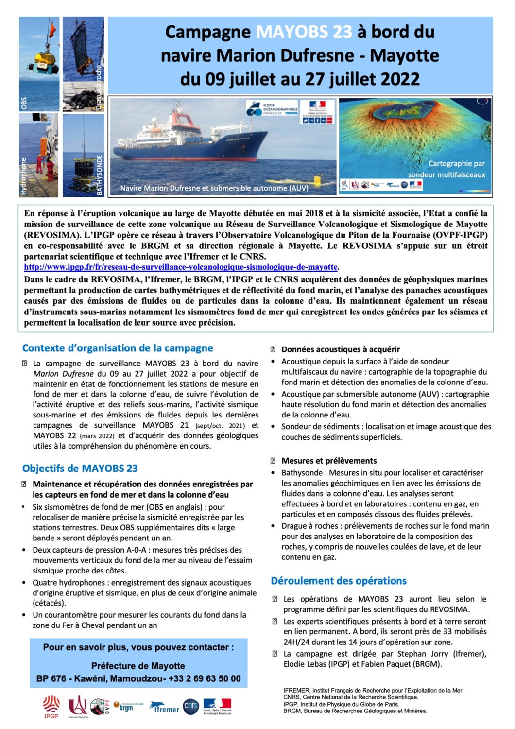 Chief scientist: Stéphan Jorry (Ifremer, UMR Geo-Ocean), Fabien Paquet (BRGM), Elodie Lebas (IPGP)
Partners: Ifremer, BRGM, IPGP, CNRS, UBO, Université Clermont Auvergne, Université de La Rochelle
Geographical zone: Mozambique Channel, east of Mayotte
Dates: 9-23 July 2022
Ship: R/V Marion Dufresne
Equipment: Rock dredge, multibeam echosounder, submersible AsterX, submersible camera SCAMPI, bathymetric sounder, RDI acoustic Doppler current profilers (ADCP), 6 OBS (Ocean Bottom Seismometers), 2 AOA pressure sensors, 4 hydrophones, current profiler
Objectives: In the context of a series of actions led by the authorities to better understand the seismo-volcanic phenomenon that has affected Mayotte since May 2018, a new marine surveillance campaign was organized off the island from 9-23 July 2022 by the Mayotte Volcanological and Seismic monitoring network (REVOSIMA), onboard the Marion Dufresne.
The objective of the MAYOBS23 campaign was to pursue underwater mapping and to conduct maintenance work on the seabed and water column monitoring stations to follow the evolution of seismo-eruptive activity, underwater relief developments and fluid emissions since the last monitoring campaign MAYOBS21 (September 2021) and acquire geological data for further understanding of the current phenomenon.
Access to the French Oceanographic Cruise Catalog: marine expedition MAYOBS23
Marine expedition MANTA-RAY
 Chief scientist: Frauke Klingelhoefer (Ifremer, Geo-Ocean) ; Boris Marcaillou (CNRS, Laboratoire Géoazur UMR 7329 / UR082)
Partners: Jean-Frédéric Lebrun (Université des Antilles) ; Romain Jatiault (CEFREM, Université de Perpignan) ; Marianne Conin (Université de Lorraine) ; Heidrun Kopp (Geomar, Kiel, Allemagne)
Geographical zone: North-west Atlantic Ocean, Caribbean Sea
Dates : 30 April - 25 June 2022
Ship : R/V L’Atalante
Equipment : Multibeam echosounder, Calypso corers, piezometer, CTD-probe, optical spectrometer, multi-trace seismic, wide-angle seismic
Objectives :
In the Lesser West Indies, the Caribbean plate overlaps with the North and South American plates. This overlapping phenomenon is subduction, and is responsible for the region’s highly active seismicity.
During three scientific expeditions between 2013 and 2016 (Antithesis 1, 2 and 3), we observed that the North American plate subduction here is inconsistent with other ocean crusts in the Pacific Ocean. This difference is probably related to the composition of the rocks of the Caribbean plate, which would be of mantellic rather than magmatic origin. Mantellic rocks can contain up to 15% more fluids (mixture of liquid and gas) than magmatic rocks in a so-called “normal” ocean crust. Their presence in the zone between the plates can produce earthquakes of varying intensity: this is the seismogenic zone.
The Manta-Ray expedition is a scientific study of the subduction zone of the Lesser Antilles to determine its geological properties and reconstruct the circulation of fluids within it, and so better understand the seismicity of the region.
The expedition holds two objectives:
- Identify the structures of fluid outflows through bathymetric surveys of the seabed, then sample the structures, perform chemical analysis of the fluids, and then understand how they circulate and accumulate in sediments by measuring pressure variations.
- Map the structure of the crust in this area using indirect acoustic methods to understand its genesis and composition.
Follow the MANTA-RAY EXPEDITION
Access to the French Oceanographic Cruise Catalog: MANTA-RAY
Marine expedition MARGEST
 Chief scientists (at sea): Pascal Le Roy (Université Bretagne Occidentale, UMR Geo-Ocean), Samuel Etienne (Service Géologique de Nouvelle Calédonie, Georisques Bordeaux);
Chief scientist (in the lab): Stephan Jorry (Ifremer, UMR Geo-Ocean)
Team members:
- At sea: Gwenaël Jouet (Ifremer, UMR Geo-Ocean), Axel Ehrhold (Ifremer, UMR Geo-Ocean), Pauline Dupont (Ifremer, UMR Geo-Ocean), Martin Patriat (Ifremer, UMR Geo-Ocean);
- In the lab: Julien Collot (Service Géologique de Nouvelle Calédonie), Elsa Tournadour (EPOC), Christophe Prunier (Université Bretagne Occidentale, UMR Geo-Ocean), Estelle Leroux (Ifremer, UMR Geo-Ocean), Walter Roest (Ifremer, UMR Geo-Ocean).
Geographical zone: South-west Pacific Ocean, east lagoon New Caledonia
Dates: 9-27 April 2022, Nouméa/Nouméa
Ship: R/V L’Alis
Equipment: Dredge, Shipek grab, Kullenberg corer, video module, side-scan sonar, single and multichannel seismic reflection, multibeam bathymetry EM1002
Objectives: The MARGEST campaign carried out from 9-27 April 2022 on board the R/V ALIS aims to gain a better understanding of the evolution and stratigraphy of the modern mixed silicoclastic/carbonate tropical platform on the eastern margin of Grande Terre in New Caledonia. This cruises follows a previous study of the south-west platform (Calgon Campaign, 2004; Calico Campaign, 2013) carried out by the same collaborative research team combining members from the Geological Service of New Caledonia, Ifremer and the University of Brest.
The main objectives of this campaign were to:
- Identify in detail the stratigraphic architecture of the eastern platform of Grande Terre by including the internal platform, the paleochannels, the passage systems and their outlets through the reef barrier;
- Constrain current sediment transfer processes across the shelf and understand sedimentary partitioning;
- Understand the potential control of Neogene tectonics on Quarternary sedimentation.
The 17-day campaign (Noumea/Noumea) on the R/V Alis focused mainly on the lagoon domain and the upper slope (up to 400 m depth) of the eastern margin, combining multi-beam bathymetry acquisitions, side-scan sonar imaging, single and multichannel sparker seismic and sampling with the Küllenberg corer, Shipek grab, dredge, and video module and sidescan imagery.
The study area covers nearly 200 km between the latitudes of Yaté in the south and Ponérihouen in the north. The areas of Cap Bayes de Thio and Kouakoué were particularly well covered with geophysical surveys and sampling along transects from the coast to the upper slopes.
Access to the French Oceanographic Cruises Catalogue: marine expedition MARGEST


Marine expedition FOCUSX2
Chief scientist: Marc-André Gutscher (CNRS Geo-Ocean)
Partners: Ifremer, IDIL (Lannion), Geomar (Kiel) ; Univ. Kiel ; INGV Rome ; Univ. Catania ; laboratoire de physique à Catania INFN-LNS.
Geographical zone: Mediterranean Sea, off the coast of Sicily in the Ionian Sea
Dates : 13 - 28 January 2022
Ship : R/V Pourquoi Pas ?
Equipment : OBS, coring, AUV IdefX
Objectives :
FocusX2 is the second cruise of the European Research Council project FOCUS.
The FOCUS project seeks to validate the technique of measuring seabed deformations using an optical fibre (laser reflectometry).
During the first part of the FocusX1 cruise project, a fibre optic cable of 6 km was connected to the cabled observatory and deployed across a submarine fault 25 km off Catane (an urban area of 1 million inhabitants). We also deployed eight seabed geodetic stations to try to calibrate the observations of the fibre optic cable.
The first objective of the FocusX2 campaign is to deploy about 30 Ocean Bottom Seismometer (OBS) that will be part of a large passive seismic network, which includes permanent land-based stations as well as 15 temporary stations (operated by INGV). This network will make it possible to detect earthquakes, locate them precisely and quantify their magnitudes.
A second objective was to collect sedimentary cores to conduct a paleoseismological study of turbidites, characterize the mechanical properties of the slope sediments, and analyze the interstitial fluids, coming from hydrothermal circulations through the fault that could modify its rheological behavior (serpentinization).
A site survey with the AUV IdefX provided detailed mapping of the seabed, imaging the morphology and fine structures formed by the active processes at the bottom of the sea.
Access to the French Oceanographic Cruises Catalogue: marine expedition FocusX2