
Offshore observation
Within the context of the Earth Sciences Observatory at the IUEM (European Institute for Marine Studies), Geo-Ocean manages three offshore acoustic observatories for acoustic monitoring of ocean seismicity and whale behaviour:
- The OHA-SIS-BIO, Observatory of HydroAcousticity from SISmicity and Biodiversity, in the Indian Ocean
- The HYDROBS-MOMAR Observatory in the Atlantic Ocean, south of the Azores
- The MAHY - MAyotte HYdroAcoustique Observatory
These observatories implement a network of hydrophones with an autonomy of between 12 and 18 months, to capture the low-magnitude seismicity associated with the active regions of the ocean floor (ridges, transform faults, hydrothermal sites) which are located too far from onshore seismic detection networks.
The objective is to acquire continuous time series, as representative as possible of the tectonic and magmatic "bottom" activity of the active structures. However, this is entirely dependent on the availability of national naval resources, which ensure the annual maintenance of the networks.
This observation work aims to:
- Automate data processing and provide catalogues of acoustic events to the scientific community
- Make the most spectacular results available to the general public
- Expand the user community, in part through joint acoustic monitoring of whales
- Upstream research on the origin of the acoustic waves (conversion of seismic waves to acoustic waves on the ocean floor) and long-range propagation of low-frequency waves.
On a European scale, Geo-Ocean is the first research entity to develop and implement autonomous hydrophone technology in the deep-sea domain. Globally, NOAA’s Pacific Environmental Laboratory, with which Geo-Ocean has been collaborating since 2000, was the first laboratory to develop this technology in the civil domain.
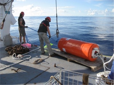
- The hydrophones (orange cylinder in the photo, yellow rectangle in the diagram) are immersed in the axis of the SOFAR channel, a low-speed ocean layer in which low-frequency acoustic waves can propagate over thousands of kilometres.
- The anchor line consists of a lost ballast (chain links), an acoustic release device, a line of several thousand metres, and a buoy (Photo) that houses the instrument. The line is adjusted for the sensor to be immersed in the SOFAR axis (between 800 and 1200m depth depending on the latitude).
")