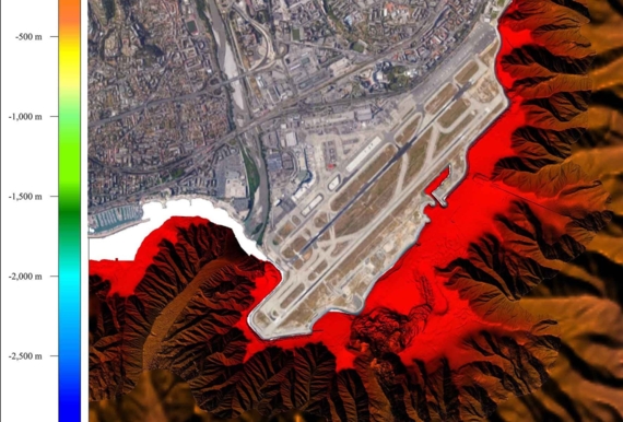
Nice: towards better prediction of submarine landslide hazards
In which circumstances an event equivalent to the 1979 catastrophic submarine landslide off Nice may recur? In an attempt to address this question, a Franco-German research project called Modal was instigated on February 15, 2018 by Ifremer, GéoAzur and their German partner Marum. The project is financed with support from the Agence Nationale de la Recherche (French Research Agency) and its German equivalent and focuses on a category of hazards identified as a priority by the Stratégie Nationale pour la Mer et le Littoral (French Sea and Coastal Strategy) (2017)
On 19 October 1979, a major landslide at the edge of the international airport of Nice provoked a small tsunami, the rupture of submarine cables in the bay and sadly, the loss of human lives. An event of this kind is likely to recur and we therefore urgently need to conduct a hazard assessment of the area.
Sediment deformation: ongoing along the coast
Sediment accumulates on the shallow platform bordering the coastline and the deposits they create sometimes produce submarine avalanches down the continental slope into the abyssal plains. There are a number of causal factors:
- Strong regional seismicity
- Heavy inflow of river sediment during flooding of the Var
- Groundwater seepage through coastal aquifers
- Low resistant clay layers
A research initiative entitled ISIS, coordinated by Ifremer from 2006 to 2008 and financed by the ANR, allowed us to gain a better insight into the cause of the 1979 landslide and in particular the role of groundwater, showing a peak in water table levels coinciding with the time of the landslide. It also led to identify a zone of instability and a suggestion that slow-movement as a continuing shear deformation was ongoing.
A novel measuring device in the marine field
Nabil Sultan, one of the project coordinators and head of Marine Geosciences at Ifremer: « What is the deformation rate? Can we quantify the link between the level of groundwater and the rate of slope displacement? And at which point may we expect a landslide? What is the probability of an event comparable to that of 1979 occurring in the near future? Modal aims to provide the answers we need to these questions » and notably with the adaptive use of a novel measuring device, the inclinometer.
This technique is commonly used on-shore and consists of staking a sort of vertical lance into the sediment. The depths of 50m anticipated in this project aim to go through the weak layer to anchor the lance in an intact layer. The tilt of the lance will evaluate deformation rate of the weak layer over a given time period. Two inclinometers will be designed and manufactured for specific use on the seabed. Their installation will be very different to those on-shore: they will each be wound around a drum measuring two metres in diameter and then rolled out and straightened before being vertically pushed through the sediment with the Penfeld, a geotechnical measuring tool designed at Ifremer for work at depths down to 6000 metres. The spot measurements made by the inclinometers will be completed by recursive bathymetric analyses over the whole geographical study area.
The inclinometers will be connected to the submarine observatory EMSO Nice. This data will complement data transmitted in real time from 20 to 30 m deep since 2015 by other instruments present on site: three piezometers relating pressure in the sediment for depths down to 30m and the broad-band seismometer which monitors ground movement provoked by near and distant earthquakes.
- The Franco-German research project Modal (Monitoring seafloor deformation and assessing landslide hazards associated with fluid pressures – Nice slope), is financially supported by the French Agence Nationale de la Recherche (ANR) and the German Research Foundation (DFG). Modal is coordinated by Ifremer and the Marum (Center for Marine Environmental Sciences), in partnership with the joint research unit Geoazur (CNRS, University of Nice Sophia Antipolis, Observatoire de la Côte d’Azur and IRD).
- The underwater observatory in Nice is an integral part of EMSO (European Multidisciplinary Seafloor and water column Observatory), established in October 2015 and conjointly managed by Ifremer and CNRS. Photos and videos at espace presse de l’Ifremer
- French national strategy for ocean and coastal management Décret n° 2017-222 du 23 février 2017 Stratégie nationale pour la mer et le littoral


